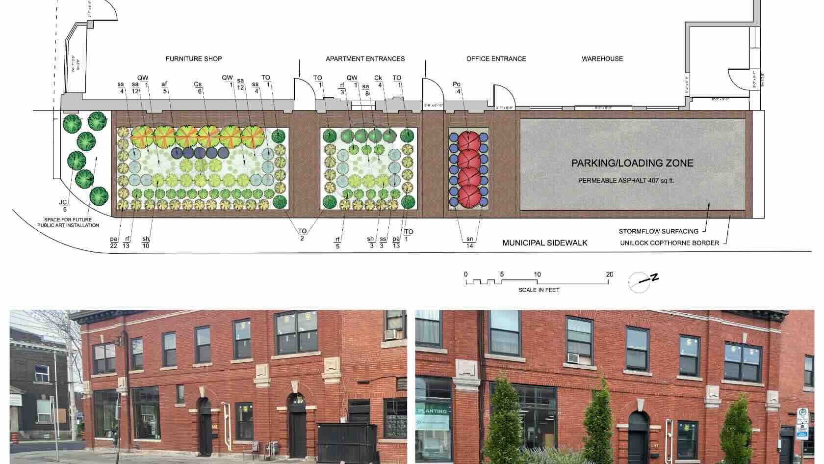
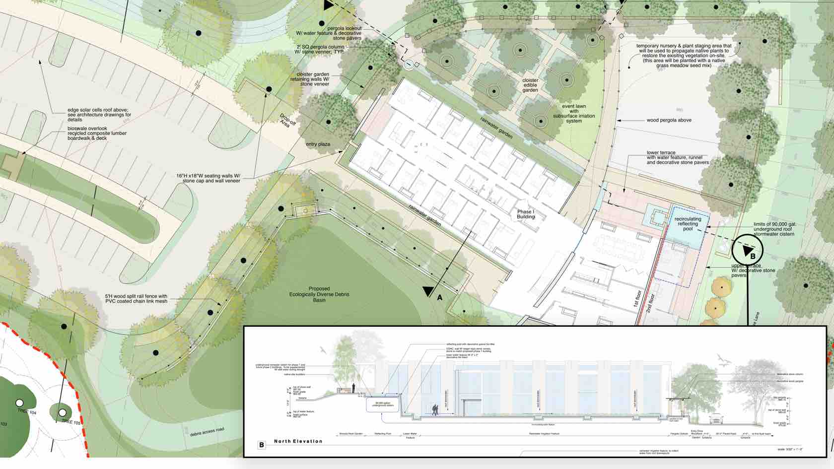
In this session, Adele Pierre of Adele Pierre Landscape
Architect Inc. will demonstrate how small-scale interventions can create
significant, positive change in urban settings. In the City of Hamilton,
Ontario, city-owned boulevards have been converted from asphalt into vibrant
rain gardens and pollinator habitats, creating a cohesive green space in a
highly industrialized neighborhood. This webinar will follow the process of
site selection, information gathering, garden creation, and documentation of
environmental impacts.
To receive 1 LA CES PDH and 1 APLD CEU, please make sure to login and complete the quiz after watching our webinar.
Landscapes
Landscapes
50m
Beginner
Learning Objectives
Explore how integrated GIS assists evaluating
potential sites and creating georeferenced base plans.
Understand how cost-effective public green
spaces can be designed for easier installation.
Identify how design intent and environmental
benefits can be communicated to the public.
Recognize how several projects cumulatively
scale up the environmental impact. Plus, learn how annotation features can aid
in reporting and communicating said impact.
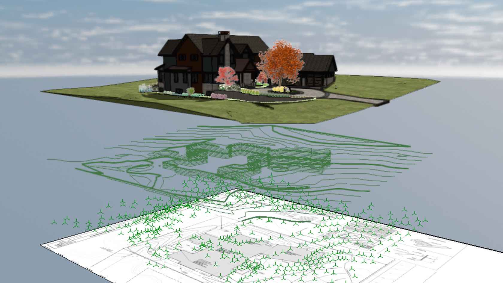
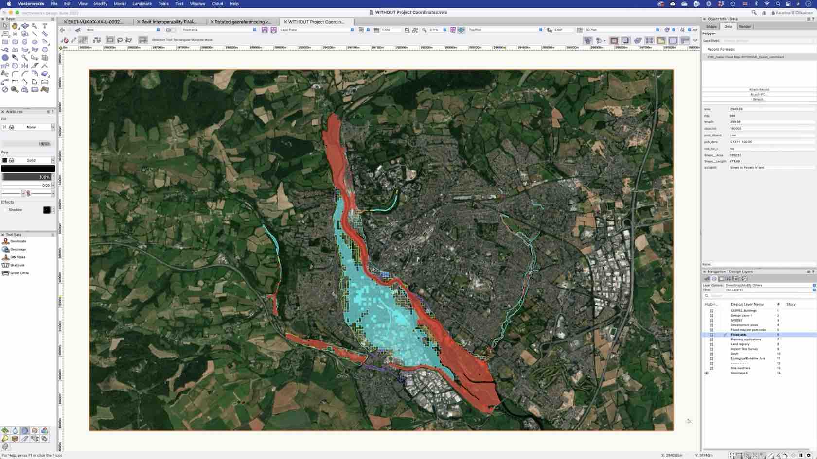
Vectorworks’ Geographic Information System (GIS) features enable the geolocation of your projects, whereby geolocation aligns the file's internal origin with the project's actual location on the Earth. During the webinar, you will learn how to locate your virtual projects, and access to public available GIS data in order to transform your site analysis, landscape and urban design workflows.
Vectorworks’ GIS tool set provides you with the ability to virtually locate your projects using real-world coordinates. These tools, in conjunction with publicly available GIS data, facilitate higher-quality analysis and outcomes for urban, concept, and pre-design workflows.
Buildings/Landscapes
Buildings/Landscapes
2h
Intermediate
Learning Objectives
Have the concepts of Geographic Information Systems (GIS) and Mapping Grids explained.
In conjunction with Document Referencing settings, learn how to use the Geoimage and Geolocate tools.
Discover how and where to source public GIS data.
Gain a deeper understanding of the methods of concept and urban design and data visualisation.
Learn when – and when not – to use GIS.
Learning outcomes relate to the following Performance Criteria from the National Standard of Competency for Architects: PC 26, PC 30, PC 32.
Data Difference: Digital Workflows for Better Collaboration with Ecologists
With continuous development of technology
and legislation, this webinar focuses on digital tools and workflows that can
enhance the collaboration between landscape architects and ecologists. Joined
by Matthew Davies, a QGIS specialist from Maplango, it showcases a case study
and a habitat-rich landscape project in both Vectorworks and QGIS. The aim is
to optimise file exchange and look at the effective ways to create planting
plans for biodiversity enhancment purposes.
Following the standard project delivery,
the webinar's content places emphasis on data and a difference that GIS and import/export
capabilities in Vectorworks make for landscape professionals and their design
decisions. While the naming conventions can vary amongst the landscape
disciplines, digital tools can help to optimise the collaboration and ensure a
greater level of communication between the landscape professions.
Landscapes
Landscapes
54m
Beginner
Learning Objectives
Learn
about the data difference in Vectorworks and explore the import/export options,
GIS capabilities and features that help your communication with ecologists.
Get
an insight into digital workflows that can help you to optimise project deliverables
for better collaboration with QGIS users.
Explore digital tools and naming conventions
that can help you to create planting specifications that support habitat
creation in ecological terms.
Discover the power of digital tools for optimizing site
analysis in your projects.
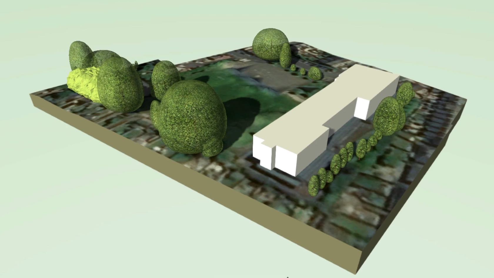
In this webinar, you'll learn advanced data import
techniques and innovative approaches to working with both 2D and 3D
topographical surveys. Plus, you’ll discover how to develop sustainable
landscape designs by leveraging site model data to assess slope, elevation,
surface water flow, and site context using georeferencing and satellite
imagery.
With these insights and more, you can confidently handle
early-stage design decisions.
To receive 1 LA CES PDH and 1 APLD CEU, please make sure to login and complete the quiz after watching our webinar.
Landscapes
Landscapes
40m
Beginner
Learning Objectives
Discover how different file setup and import
options can optimize your project’s BIM workflow.
Understand the benefits of GIS feature
layers when making early-stage design decisions.
Explore new ways to work with
topographical surveys in both 2D and 3D views.
Learn best practices for site
evaluations and creating sustainable landscape schemes.
Site analysis tools and technologies can boost your workflow efficiencies from design to installation.
Join Joe Hanauer,
registered landscape architect, and owner of Landscape
Architecture, LLC., for a webinar on how to use design software and other apps
and hardware to collect information, synthesize the data, and communicate ideas
to customers.
Hanauer will also cover the integration of complementary technologies used to collect site data. Save time site surveying, creating base information and increase the accuracy of design projects.
To receive 1 LA CES PDH and 1 APLD CEU, please make sure to login and complete the quiz after watching our webinar.
Landscapes
Landscapes
50m
Intermediate
Learning Objectives
Learn
how the use of a GPS surveyor can increase the accuracy of in-house surveys and
create more accurate project drawings.
Understand
the limitations of a GPS surveyor and how a mobile device and point cloud
capture can offer a solution.
Create
efficiencies from design to construction with design software tools that can be
used to uphold design standards and improve project layout.
NOTE: This seminar is now available on-demand. Please click the Register button above to register and view the seminar now.
Are you ready to embark on your journey with Vectorworks Landmark? Look no further! In this engaging introductory session, we've meticulously distilled the essential tools, concepts, and workflows you need to kick-start your Vectorworks Landmark experience.
Whether you're a novice taking your first steps or someone seeking a quick and practical overview, this one-hour seminar is your perfect gateway to the world of Vectorworks Landmark. Join us as we unravel the key components of Vectorworks Landmark,
offering you a comprehensive overview of this powerful design software. Our aim is to provide you with a concise, yet informative introduction to Vectorworks Landmark that empowers you to start creating landscape designs with confidence. While this
session may be just an hour long, it will set you on the right path, equipping you with the fundamental knowledge needed to explore Vectorworks Landmark further.
Landscapes
Landscapes
1h 3m
Beginner
Learning Objectives
Familiarize yourself with Vectorworks Landmark and its user-friendly interface.
Gain insight into the core tools and functionalities that form the backbone of Vectorworks Landmark.
Understand the standard landscape design workflow of Vectorworks Landmark.
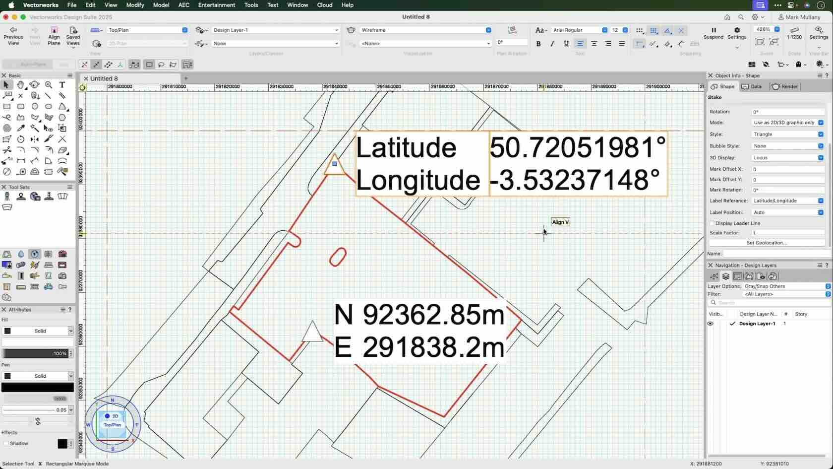
In this coffee break, we'll examine all the moving parts in correctly placing a project in the world. Even if you're not required to georeference your project, you can benefit from it, simplifying things like working in Project North.
We'll also go through a step-by-step checklist for correctly setting up new files and fixing old ones.
All Industries
All Industries
52m
Intermediate
Learning Objectives
Why GIS is so beneficial even if you're not required to use it.
How to set up a new project correctly.
How to fix an old project.
How to determine what is essential when exporting a file.
Designing landscapes with sustainability in mind is no longer a matter of preference but one of meeting jurisdictional requirements.
Site designers can harness the power of design software, online resources, and other digital tools to meet new expectations in water-efficient irrigation and on-site water management. And with the help of GIS integrations, plant databases, and smart 2D/3D
object design, creatively managing water in your proposed landscape is easier than ever.
To receive 1 LA CES PDH and 1 APLD CEU, please make sure to login and complete the quiz after watching our webinar.
Landscapes
Landscapes
1h
Beginner
Learning Objectives
Recognize how water needs data can be included in your plant specification workflows, which can quickly fulfill your LEED/SITES-compliant proposed landscape plan.
Learn how technology assists in water budgeting, from defining hydrozones to documenting compliance with a water allowance.
Explore integrations with GIS and other site inventorying data, which help inform pre- and post-development analysis when planning for better rainwater management.
Consider how smart 2D/3D objects in design technology can help realize proposed water management features like green roofs, rain gardens, and bioswales.
No matter who’s involved in your file exchange, it’s critical to maintain accurate project file position and origin. This is essential for efficient design and documentation workflows — and the integrity of project delivery. This presentation will review best practice workflows using georeferencing within the file organisation to integrate other CAD, BIM, and GIS files.
Landscapes
Landscapes
55m
Intermediate
Learning Objectives
Learn how to accurately georeference a project and establish a common location for all future import/export needs.
Understand how to establish a file origin while maintaining its accurate georeference.
Witness the efficiency of locating and visualising a site and its surrounding context with GIS services throughout project design and development.
The process for importing various tree survey types is simpler with location parameters for geographical and cartesian coordinates built in with the newly added GIS support for tree surveys. You’ll benefit from the new geospatial import methods when documenting existing vegetation for biodiversity and biomass considerations, and import pertinent survey area types like mass plantings, meadows and more.
Landscapes
Landscapes
2m
Beginner
Learning Objectives
Learn about the new GIS support for tree survey imports in Vectorworks 2022.
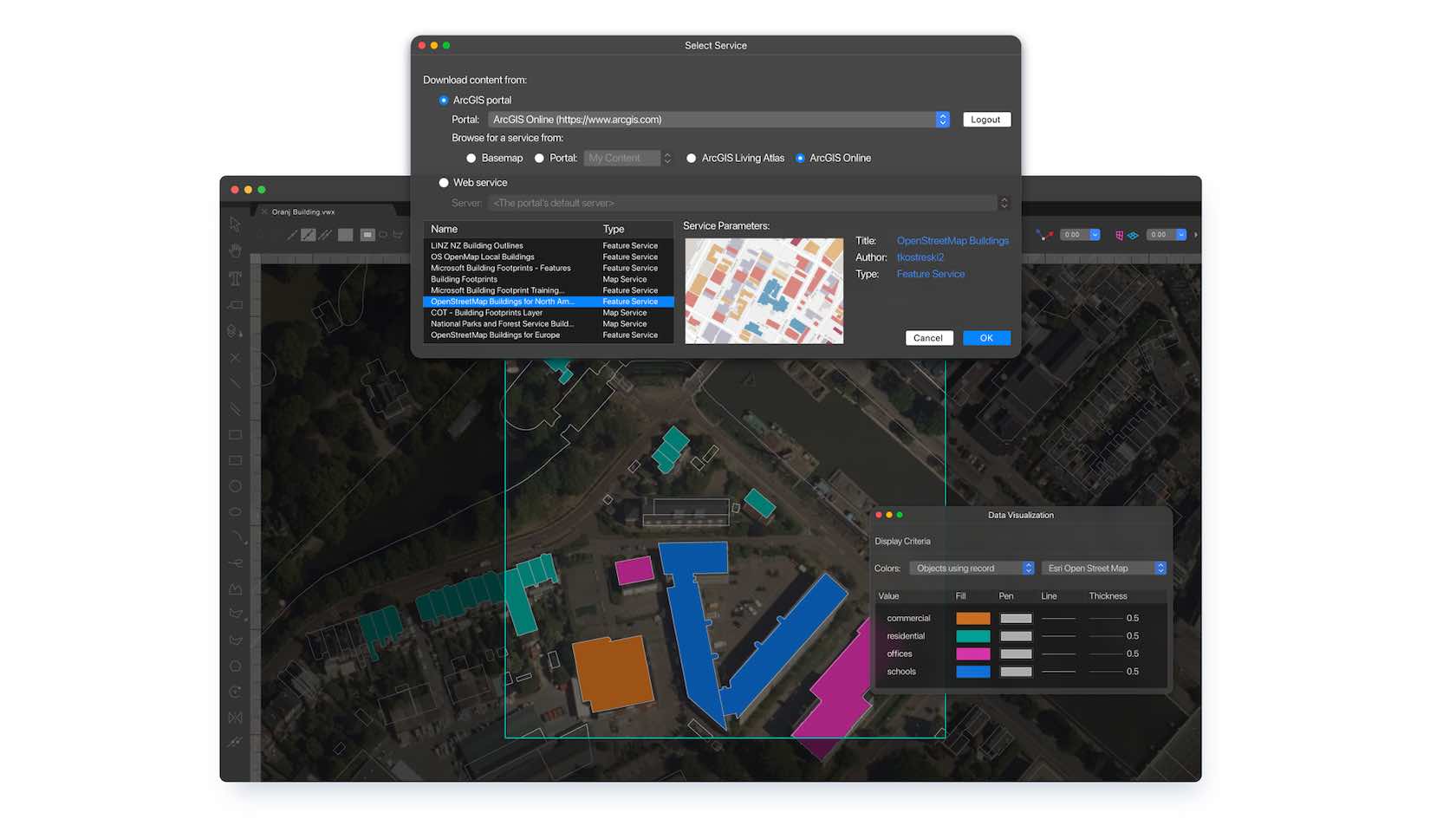
See an efficiency boost in your GIS/BIM workflows with easier integration for site planning and collaboration. In partnership with Esri, you can now access, download and incorporate an incredible amount of information into your design with the vector geometry and data using Vectorworks Layers. You’ll also be able to export and upload from Layers back to the ArcGIS Feature Layers, making it easier to manage specific geospatial data beyond traditional methods and collaborate with GIS professionals.
Buildings/Landscapes
Buildings/Landscapes
1m
Beginner
Learning Objectives
Explore the new ArcGIS Feature Layers functionality in Vectorworks 2022.