For design-build practices 2D drafting and plans can be unbelievably
effective.
Join Carl Molter of ecological design-build company
Indigenous Ingenuities for this informative webinar. You’ll learn how 2D
drawings can effectively contain both information and beauty.
To receive 1 LA CES PDH and 1 APLD CEU, please make sure to login and complete the quiz after watching our webinar.
Landscapes
Landscapes
50m
Beginner
Learning Objectives
Observe 2D design-build plans from field work to
final presentation.
Discover how a custom workgroup can speed up
drawing production.
Witness tips to efficiently manage drawing file
sizes and create phased pricing plans from a single master plan.
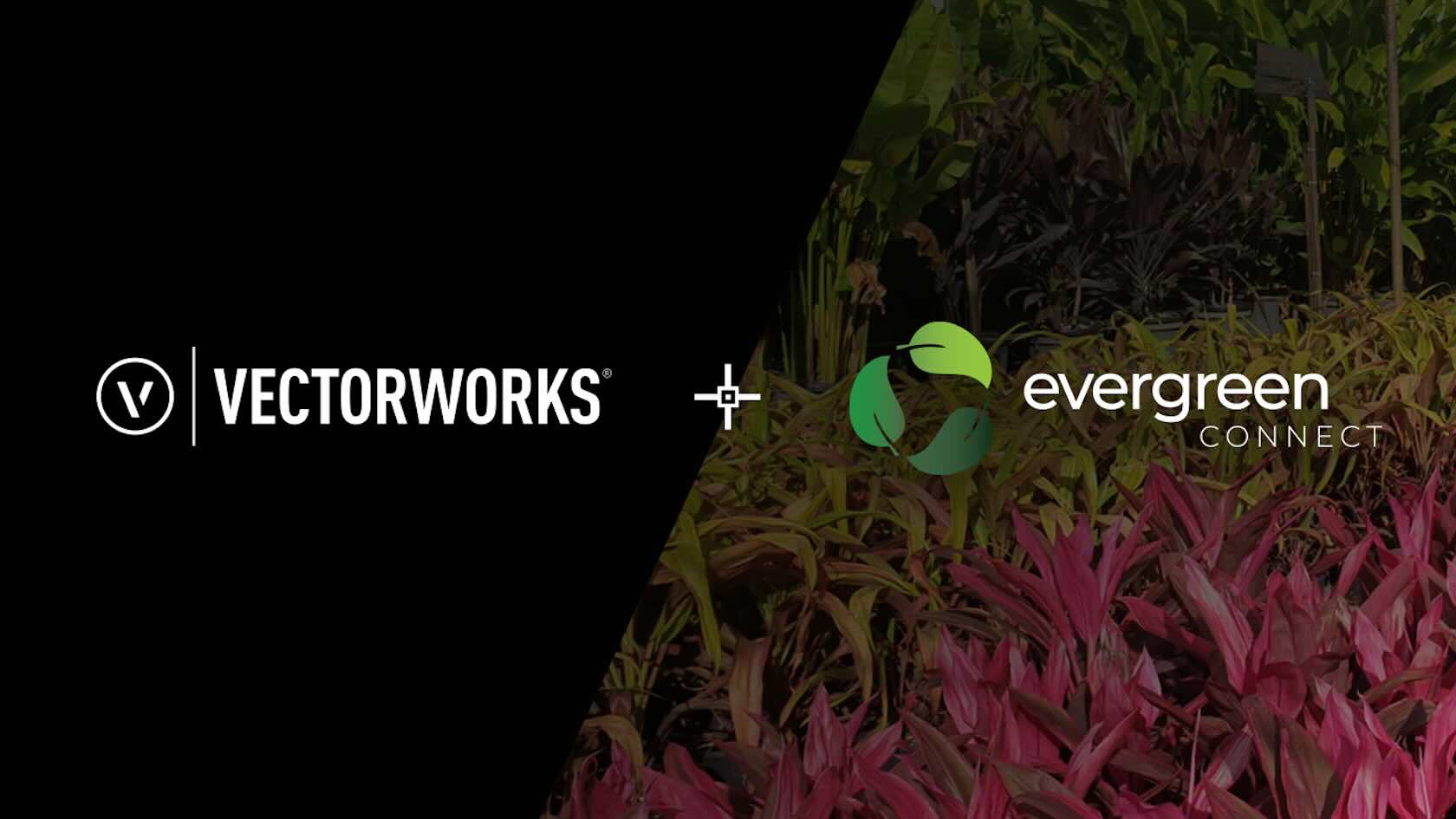
Streamlining Your Planting Plans with Vectorworks and EvergreenConnect
Learn how integrating Vectorworks with EvergreenConnect’s live plant availability data can enhance the efficiency and accuracy of your planting plan workflow. This webinar will show you how to check your Vectorworks planting plans against real-time availability and cost data from EvergreenConnect, helping you create designs that are both practical and cost-effective.
Landscapes
Landscapes
1h 4m
Intermediate
Learning Objectives
Learn how to link Vectorworks planting plans with EvergreenConnect for real-time plant availability and pricing
See how to export plant counts and selections directly to EvergreenConnect
Discover the project management features available within EvergreenConnect
Gain practical tips for improving workflow efficiency and accuracy
Participate in a Q and A session with Ben Beaumont and Todd Gallagher
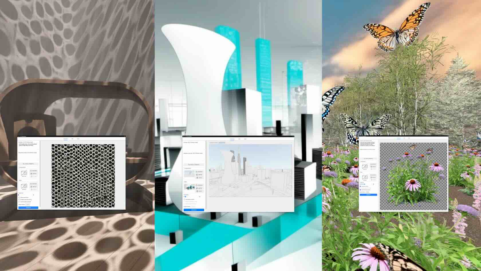
Discover how the AI Visualizer
empowers you, regardless of your industry, to create stunning visuals with
ease. Learn to apply advanced image styles, refine designs with inpainting, and
generate limitless assets directly within your existing workflows. Explore
features like prompt saving, alpha channel assets, and automated background
creation to streamline your design process.
Join Vectorworks experts for this session and
unlock new levels of creativity and efficiency with these powerful AI-driven
tools.
To receive 1 APLD CEU, please make sure to login and complete the quiz after watching our webinar.
All Industries
All Industries
50m
Beginner
Learning Objectives
Streamline workflows by learning
to craft effective text prompts and the use of image styles.
Master the creation of seamless
textures.
Produce and utilize image assets
with alpha channels.
Enhance image quality and leverage
direct resource creation.
Discover the full creative and
technical workflow behind designing a stunning modern audio console with an
integrated turntable — using only Vectorworks Fundamentals. This webinar will
guide you through the entire process, from initial concept development to design
drawings, all within a single software environment.
Learn how to leverage Vectorworks
Fundamentals to model complex furniture forms, create high-quality renderings,
and produce precise technical drawings for fabrication. Whether you're a designer
or maker, this session will give you the skills to bring your furniture ideas
to life with efficiency and precision.
All Industries
All Industries
50m
Beginner
Learning Objectives
Explore how to
generate and refine furniture designs within Vectorworks Fundamentals.
Master essential tools and workflows for creating detailed
and complex furniture forms.
Use Vectorworks Fundamentals’ rendering capabilities to
produce compelling visuals that showcase materials and lighting.
Learn how to efficiently generate accurate shop drawings
directly from your 3D model.
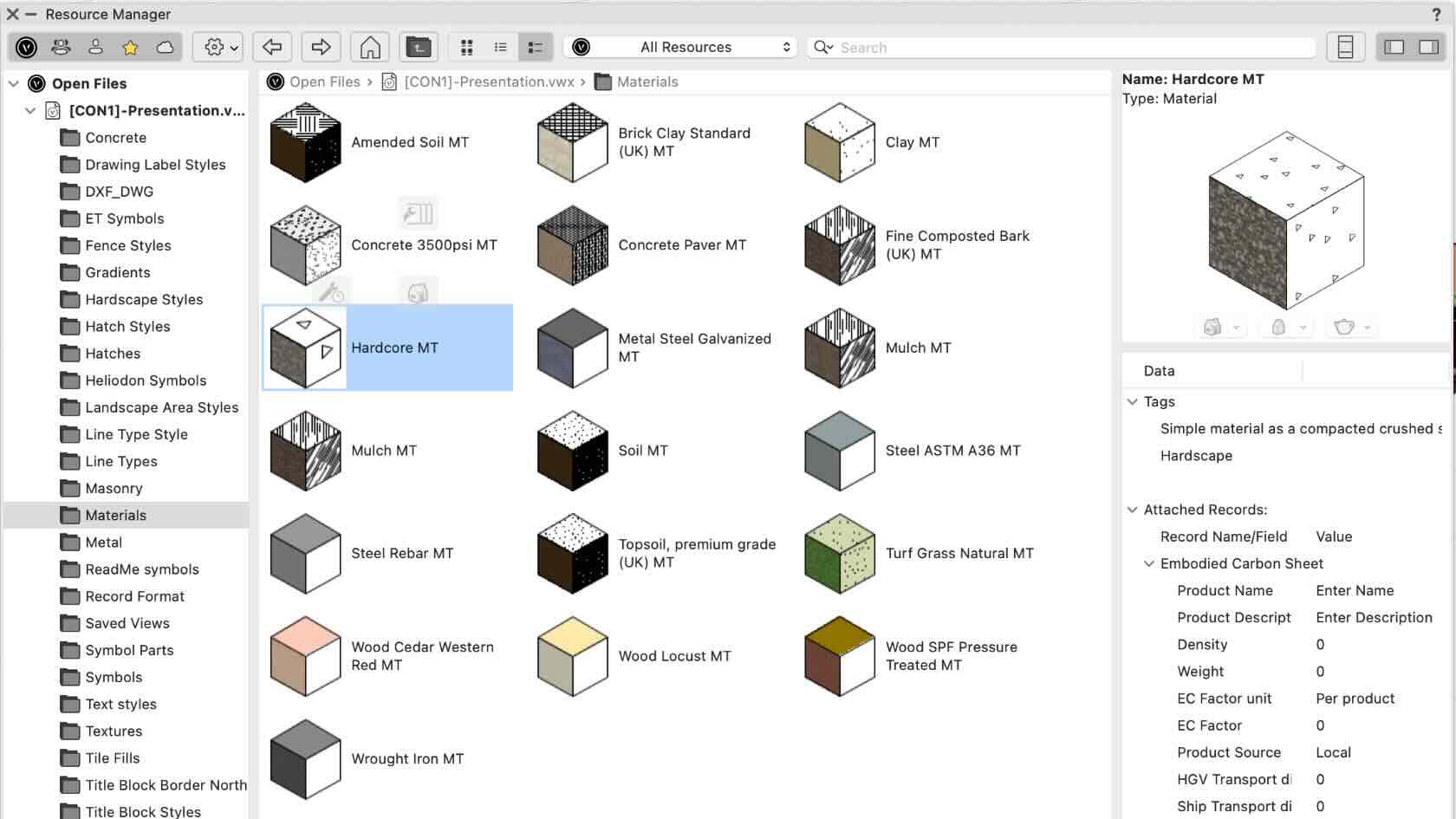
Join landscape industry expert Marketa Hermova for an enlightening webinar on estimating embodied carbon and utilizing tools that empower you to make impactful design choices regarding material and product specifications. This session will also showcase how you can actively tackle a landscape project's carbon footprint through workflows highlighted in a project case study.
To receive 1 APLD CEU, please make sure to login and complete the quiz after watching our webinar.
Landscapes
Landscapes
1h
Beginner
Learning Objectives
Get an overview of Vectorworks Embodied Carbon Calculator
(VECC), a pre-formatted worksheet that allows you to estimate the project's
embodied carbon.
Explore the data difference in Vectorworks Landmark and
learn about a custom record format for tracking a material's attributes,
properties, and embodied carbon.
Gain knowledge of the existing workflows and the embodied
carbon assessment for a project in its early or advanced development stage.
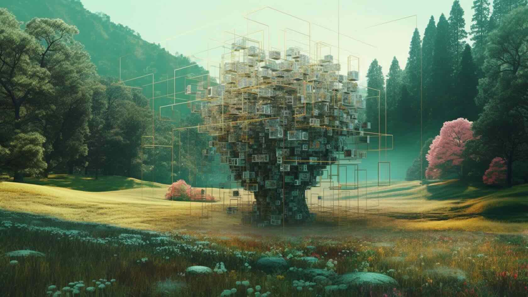
Take a tour through the world of AI-powered landscape design.
This webinar is your passport to understanding how
artificial intelligence is transforming the built environment. From Generative
AI applications optimizing design and analysis workflows to robots monitoring
wetland restoration and dry stacking stone walls, you’ll witness compelling
case studies of how AI can be a collaborator — not just a tool — in the design and
planning process.
To receive 1 LA CES PDH and 1 APLD CEU, please make sure to login and complete the quiz after watching our webinar.
Landscapes
Landscapes
50m
Beginner
Learning Objectives
Gain a reasonable understanding of the field and applications of artificial intelligence and their context in the built environment.
Examine case studies of AI integration in landscape and urban design.
Learn mental
models for human-AI partnership in the design process.
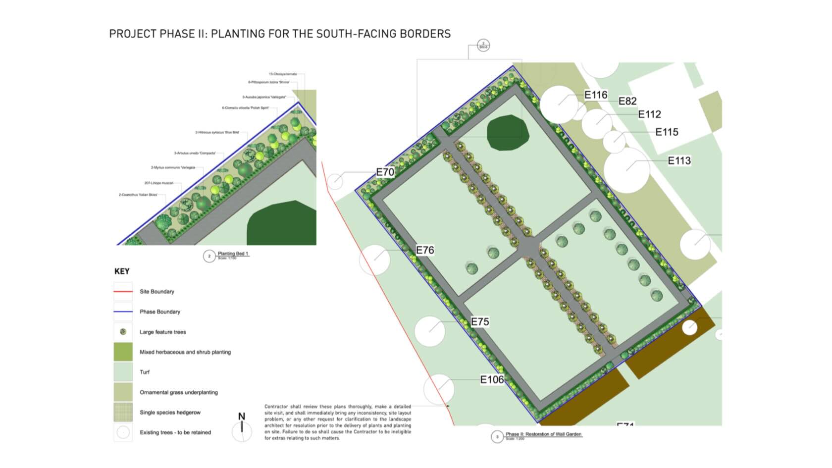
Streamlining Your Annotation Process with Callouts, Data Tags and Note Tools
Join us for the session which will dive into available digital tools to assist you when creating and managing annotations in your landscape plans. Desired visual representation of your labeled plans can be achieved, all whilst mastering the alignment of your keynotes, tags and callouts. Open for all levels, the session will focus on some of the latest improvements that will help you to stay organized and save time when creating and customizing your landscape plans.
Landscapes
Landscapes
1h 2m
Intermediate
Learning Objectives
Learn how to automate the process with the use of data tags.
Gain an understanding of Callout and Note tools to ensure clarity and consistency in your designs.
Explore the callout database and note manager while utilizing their potential to produce customized text descriptions such as disclaimers or product specifications.
Join Mardi Dover, CPLD, MardiDover.com, to learn how you can
better navigate client challenges with confidence. You’ll gather practical strategies to
manage difficult situations, set clear expectations, and protect your landscape
design business’ reputation. You’ll also discover how proactive communication,
effective boundary-setting, and solid business practices can prevent scope
creep, budget overruns, and designer burnout.
Don’t miss this opportunity to
gain actionable insights.
To receive 1 LA CES PDH and 1 APLD CEU, please make sure to login and complete the quiz after watching our webinar.
Landscapes
Landscapes
1h
Beginner
Learning Objectives
Describe the potential impacts of
failing to effectively navigate difficult situations.
List common challenges in a design
practice.
Identify strategies for managing
complex scenarios in client relationships.
Thinking about a change in your landscape design workflows may feel
daunting — we understand. But you can take on the learning curve and succeed.
And when you do, you will gain many tangible benefits.
Join Eric Gilbey, landscape architect and product marketing manager, in
this webinar as he discusses techniques for learning new software and
approaching Vectorworks Landmark from your current workflow. He will
demonstrate basic techniques to help you get started in Vectorworks, provide
tips for working smarter, not harder, share designer-shared successes, and
equip you with support resources to improve your skills once you make your move
to Vectorworks Landmark.
Landscapes
Landscapes
38m
Beginner
Learning Objectives
Acquire simple strategies when testing
Vectorworks features during your trial period.
Assess which Vectorworks Landmark features
yield significant learning and efficiency gains, improving your current design
workflow.
Gain familiarity navigating the user
interface to locate and deploy essential tools and commands for designing and
documenting your project in Vectorworks Landmark.
Access Vectorworks' instructional and
technical support resources, such as the Onboarding Paths, Vectorworks
University, and the Online Help System, to grow your knowledge and skills.
Elevate Your Experience: What’s New in Vectorworks 2025
Explore the latest updates in Vectorworks 2025 designed to boost design efficiency, streamline 3D modelling, and enhance collaboration presented by Jonathan Reeves, an architect, author, and Vectorworks expert.
Through real-world project examples, you'll discover how these new features can transform your workflow. Key highlights include Object Visibility, Two Point Perspective, Revit & DWG Collaboration, Room Finishes, and AI Visualisation updates. Reeves will also dive into exciting enhancements in Vectorworks Cloud and much more. Plus, he’ll share extra tips and tricks.
Discover how digital tools can elevate your softscape design and streamline plant specification workflows, making it easier to meet your project’s sustainability goals. In this session, we’ll guide you through incorporating metrics like Biodiversity Net Gain and Urban Greening Factor directly within your design software, eliminating the need to switch between platforms. Learn how to generate customised reports and worksheets tailored to your planting proposals. Open to all experience levels, this session will showcase new features and their benefits, empowering you to communicate your planting designs effectively with clients, contractors, and other project stakeholders.
Landscapes
Landscapes
52m
Beginner
Learning Objectives
Enhance softscape design and plant specification workflows through digital tools.
Integrate sustainability metrics (e.g., Biodiversity Net Gain, Urban Greening Factor) directly within design software.
Simplify the creation of customised reports and worksheets for planting proposals.
Offer insights suitable for all experience levels to optimise design and workflow efficiency.