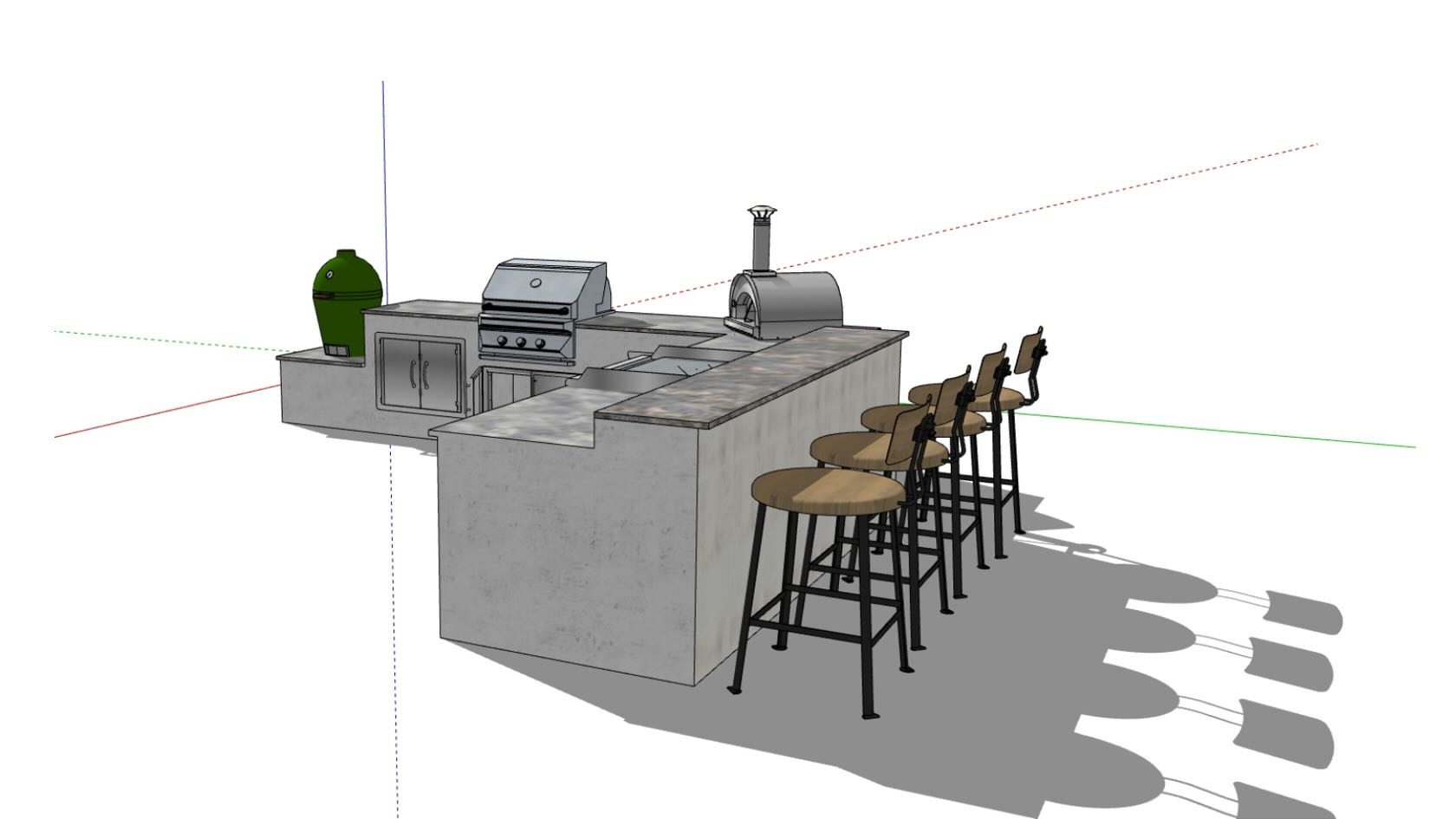
Follow the
design process of RootBound, a high-end residential design studio, from
surveying all the way through rendered models. This comprehensive webinar will
give you a complete overview of how the workflows RootBound uses helps them to
create stunning designs and win the next great project.
The webinar
will conclude with real-world examples, illustrating the power of technology-driven
efficient design workflows.
To receive 1 LA CES PDH and 1 APLD CEU, please make sure to login and complete the quiz after watching our webinar.
Video
Landscapes
1h
Beginner
Learning Objectives
Understand
the design process of a residential landscape design firm.
Witness
an overview of technology-driven workflows that meet the needs of a small firm.
Comprehend
expectations of how presentation deliverables transition to working drawings
within the context of a firm’s holistic repertoire.
Are you in your element at your
drawing board, but the ins and outs of marketing your landscape design practice
is a mystery? Effective marketing does not have to be difficult —
don’t waste time and money on efforts that attract the wrong clients and
projects. In this webinar, learn how to confidently translate information about
your client avatar into your marketing strategies to build a more profitable
and enjoyable landscape design business.
To receive 1 LA CES PDH and 1 APLD CEU, please make sure to login and complete the quiz after watching our webinar.
Video
Landscapes
41m
Beginner
Learning Objectives
Discover the importance and process of creating a client
avatar for your landscape design firm.
Learn why creating a client avatar is an essential part of
an effective marketing strategy.
Understand how you can use a client avatar to tailor your
marketing efforts and create a more profitable landscape design business.
Are you looking to build a business that consistently attracts great clients? In this webinar, you’ll learn how to streamline your marketing efforts for an efficient and effective voice that results in increased profits and more time for doing what you
love: designing beautiful outdoor spaces.
To receive 1 LA CES PDH and 1 APLD CEU, please make sure to login and complete the quiz after watching our webinar.
Video
Landscapes
45m
Beginner
Learning Objectives
Learn the importance of
finding your landscape design firm’s ideal client.
Identify the crucial
components that make up your ideal client.
Establish a compelling
brand voice that improves your firm’s marketing efforts.
Understand the
connection between compelling marketing and an effective landscape design firm.
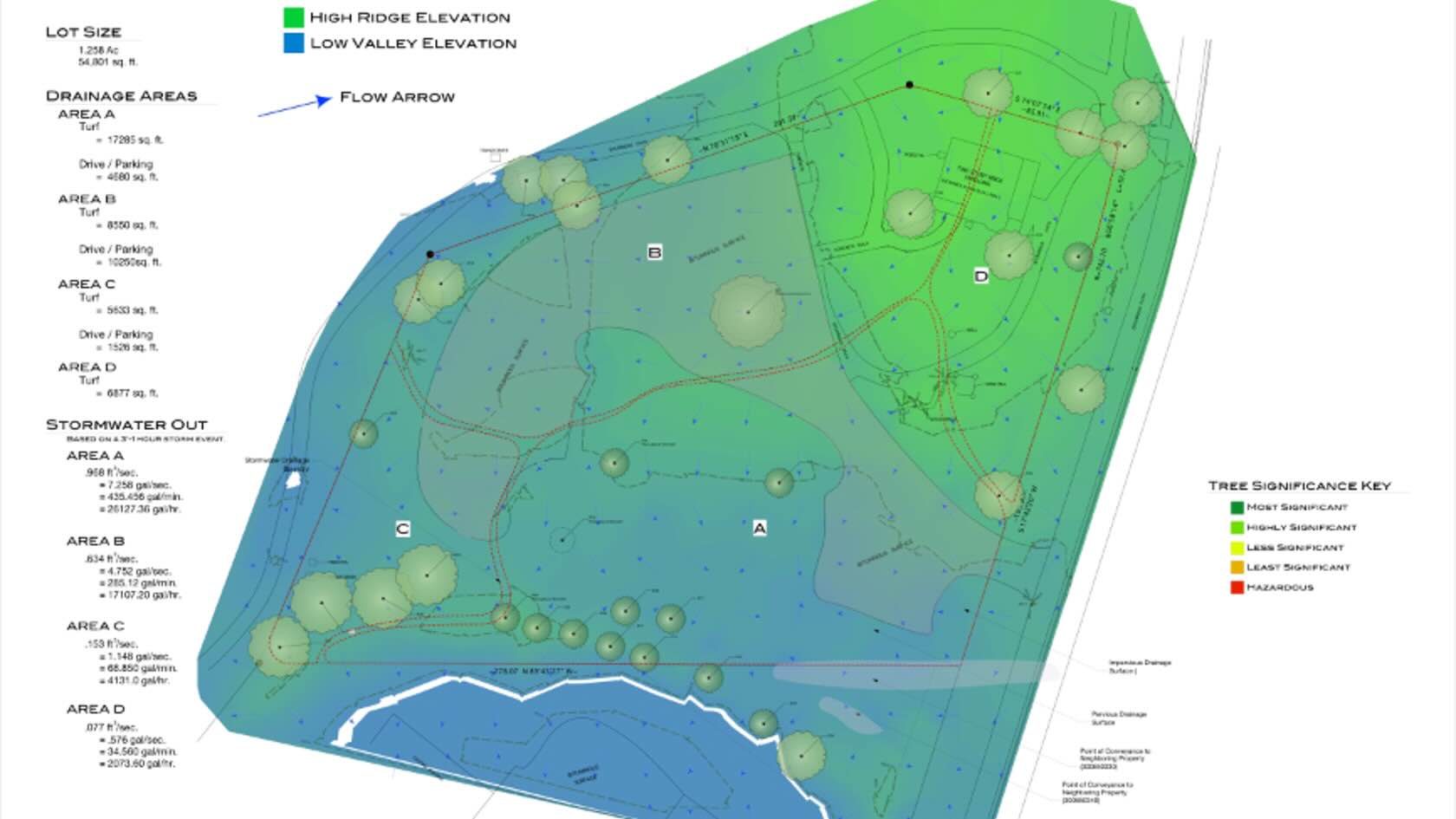
Discover the power of digital tools for optimizing site
analysis in your projects.
In this webinar, you'll learn advanced data import
techniques and innovative approaches to working with both 2D and 3D
topographical surveys. Plus, you’ll discover how to develop sustainable
landscape designs by leveraging site model data to assess slope, elevation,
surface water flow, and site context using georeferencing and satellite
imagery.
With these insights and more, you can confidently handle
early-stage design decisions.
To receive 1 LA CES PDH and 1 APLD CEU, please make sure to login and complete the quiz after watching our webinar.
Video
Landscapes
40m
Beginner
Learning Objectives
Discover how different file setup and import
options can optimize your project’s BIM workflow.
Understand the benefits of GIS feature
layers when making early-stage design decisions.
Explore new ways to work with
topographical surveys in both 2D and 3D views.
Learn best practices for site
evaluations and creating sustainable landscape schemes.
3D MODELLING FOR RESIDENTIAL LANDSCAPES IN DESIGN SOFTWARE
Join Vectorworks to
explore digital workflows in a design process, tailored to the needs of
residential landscape projects. Starting with a model of the existing site and
a 2D concept plan, we will look at the effective ways to grade the site model
surface and to work with the site model contours. Using digital tools, we will
create a 3D model of the proposed landscapes for both the front and rear
garden. Learn tips and tricks for free-form modelling and its potential to
craft sculptures for residential sites. Open for all levels, the session will
focus on some of the new features and their benefits, helping you to
communicate your design proposals with clients and contractors.
Though 3D-modeled landscapes are becoming more common in
design workflows, many still hesitate to involve valuable techniques in all
areas of their design workflow.
A key benefit to incorporating 3D and BIM in your landscape
design, beyond selling, is analysis. In this session, you'll learn how to
leverage the power of solar, terrain, building, and landscape feature modeling
to better analyze site conditions, advise clients, and validate design choices.
By integrating 3D with 2D design workflows, there's less
disruption in getting to a sellable, better-performing solution for your
clients.
Video
Landscapes
50m
Beginner
Learning Objectives
Recognize how modeled terrains can visualize grade changes
and analyze for cut/fill, slope, and surface drainage flow.
Understand how sun and shade studies can analyze existing
conditions and propose landscape solutions to your clients.
Realize where integrating 3D workflows can be less
disruptive to design development and build efficiencies for each subsequent
project.
Learn how 3D objects can provide crucial estimating data for
costing and material reports.
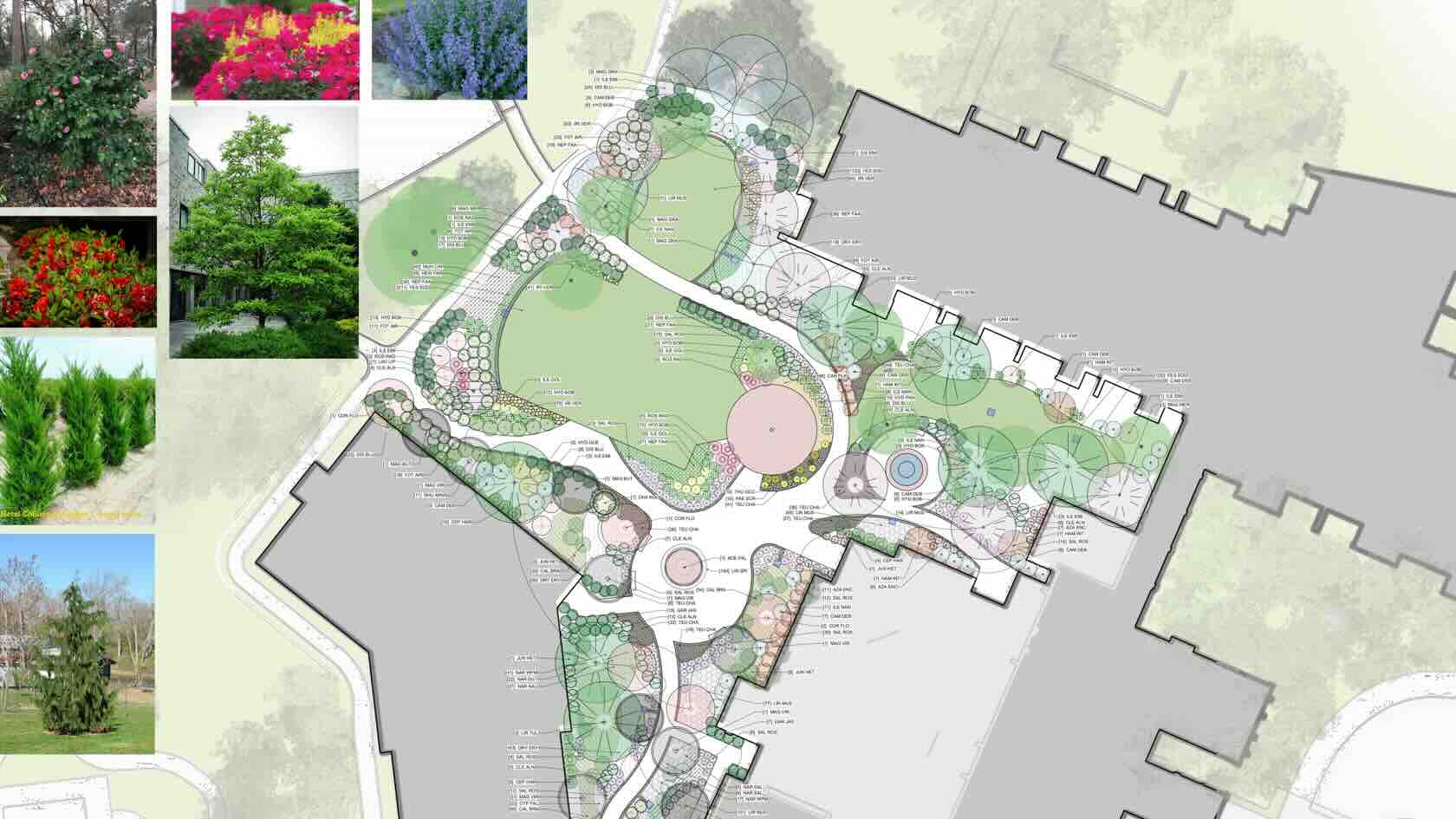
Join Vectorworks on creative journey
of crafting customised symbols, materials and other resources that can help you
to create bespoke landscape plans. In this session, we will share some of the
tips and tricks to generate your own resources in 2D and 3D. Using workgroup
libraries, we will explore ways to save, edit and share content with your
colleagues and project co-workers. Stay on track with updating your firm’s
libraries while using customised content and producing plans that meet the
industry standard. Suitable for all levels, we will explore some of the new
features that can help you to optimise the graphics of your landscape plans and
specifications.
Combine the strength of Vectorworks with the speed of AI image generation powered by Stable Diffusion. Directly available within the Vectorworks interface, this experimental feature uses Vectorworks Cloud Services for a zero-install, uninterrupted workflow to quickly ideate illustrative concepts or create refined images using your Vectorworks models at any stage of design.
Video
All Industries
5m
Beginner
Learning Objectives
Explore the new AI Visualizer released with Vectorworks 2024 Update 4.
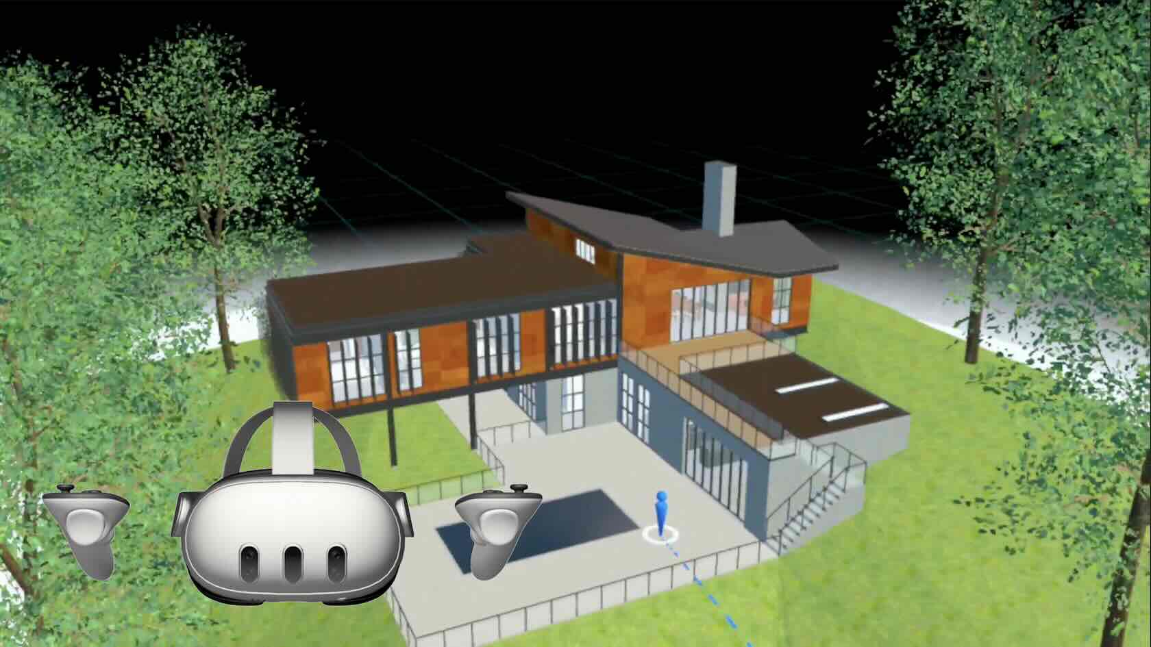
Explore your designs with Vectorworks Odyssey, a virtual reality viewer app created for Meta Quest 2 headsets and beyond. Experience models in immersive VR with bird's-eye view and walkthrough modes. Gain better context for quick and thorough feedback, including cycling through design options with access to design layer visibilities.
Video
All Industries
3m
Beginner
Learning Objectives
Explore the new Vectorworks Odyssey viewer for Meta Quest 2 headsets, released with Vectorworks 2024 Update 4.
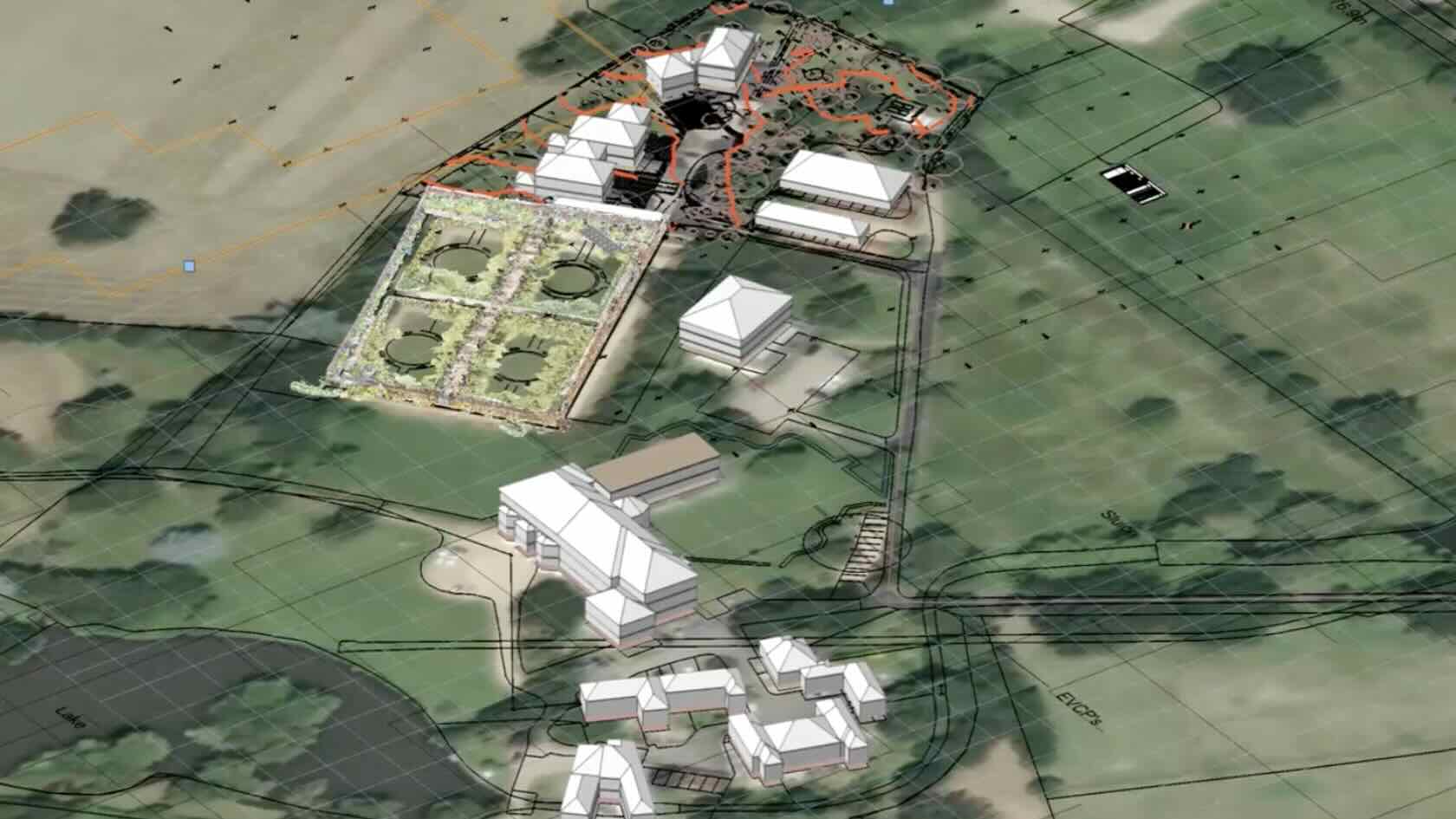
In this webinar, you’ll
observe a phase-by-phase breakdown of an urban landscape design project. By
demystifying the design process, you’ll discover effective ways to use
technology to deliver your work in multiple design phases of a landscape
project. Click here to access The Cube Landscape Project sample file.
To receive 1 APLD CEU, please make sure to login and complete the quiz after watching our webinar.
Video
Landscapes
40m
Beginner
Learning Objectives
Identify the benefits of
design software across multiple landscape design phases.
Understand the
professional competencies of digital design and project management.
Witness innovative
approaches to project problem-solving with design software.
Comprehend the
intersection of landscape design, digital technology, visualization, and camera
effects.
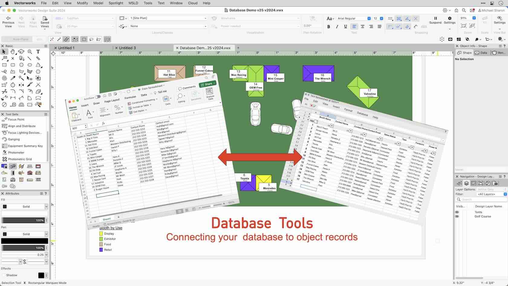
In this course, we'll learn how to connect an external database to the records in our drawing. Using SQLite as a database source, we'll quickly fill our records with data without having to manually retype anything.
Video
All Industries
15m
Intermediate
Learning Objectives
Explore the Database commands and tools.
Connect an external SQL database to our existing records.
Transfer our data back and forth between our model and the external database.
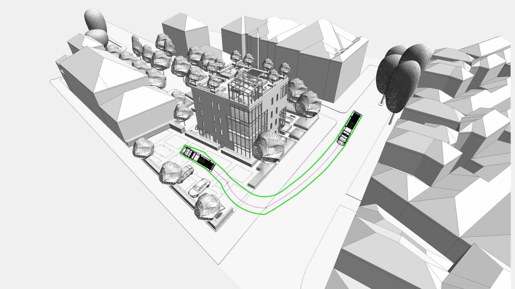
Looking to up your game regarding
the safety and efficiency of your projects?
Incorporating
Vectorworks' intuitive site design workflows is just the beginning. Take it up
a notch by utilizing AutoTURN Online, an invaluable tool that brings vehicle
turn maneuvers to life. Through these simulations, you'll gain valuable
insights into the functional and operational constraints of your project's
vehicular circulation design.
Join Andres Velez, a
civil and transportation expert, and witness the power of AutoTURN and
Vectorworks.
To receive 1 APLD CEU, please make sure to login and complete the quiz after watching our webinar.
Video
Buildings/Landscapes
50m
Beginner
Learning Objectives
Understand
the role vehicle turn simulations (swept path analysis) play in ensuring
vehicles can enter, circulate, and exit sites, parking lots, ramps, and
buildings.
Learn
critical aspects of the analysis and how it can help streamline the design and
approval process.
Explore
case studies demonstrating how this analysis can uncover design weaknesses and
potential bottlenecks.